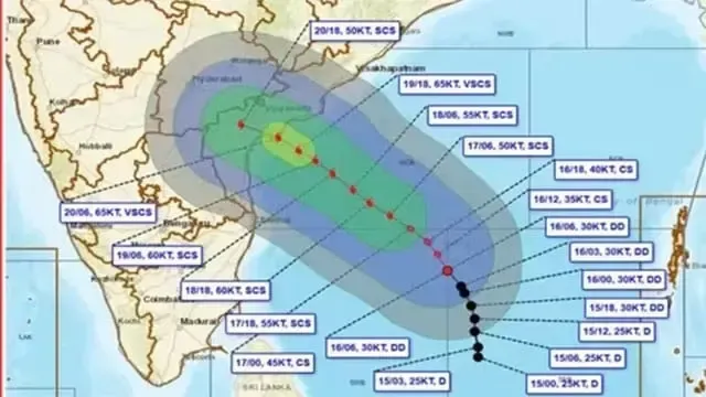
The deep depression over the Bay of Bengal has now intensified into Cyclone 'Akwan'. The India Meteorological Department (IMD) states that it is expected to further intensify into a severe cyclonic storm by tomorrow (17).
Currently centered over the south and adjoining west-central Bay of Bengal, the storm is located about 630 km northeast of Trincomalee, 610 km east of Chennai, and 660 km southeast of Machilipatnam in Andhra Pradesh.
Key Points
- Storm is centered approximately 630 km northeast of Trincomalee
- Expected to intensify into a very severe cyclonic storm by November 19
- Risk of making landfall in India on November 20
Storm's path
The system is likely to intensify across the west-central Bay of Bengal by tomorrow (17) evening and subsequently move northwestwards. It is estimated to intensify into a very severe cyclonic storm by around November 19.
According to forecasts by the India Meteorological Department, it is likely to make landfall along the Andhra Pradesh and Yanam coasts between Nellore and Tuni during the afternoon of November 20. Maximum sustained wind speeds are expected to range between 120 and 130 km/h, with gusts reaching up to 145 km/h.
Preparations for the risk
Owing to the adverse weather conditions, all districts in India's Odisha state, particularly the southern and coastal districts, have reportedly been placed on high alert.
Earlier on October 28, Cyclone 'Arnab' struck Andhra Pradesh, triggering severe floods, while Cyclone 'Murasu' brought heavy rainfall to the same region earlier this month.
What happens next?
Indian media reported that the storm is expected to cross the coast between Nellore and Tuni along the Andhra Pradesh and Yanam coastline as a very severe cyclonic storm around noon on November 20.
Read Also
- Massive contract awarded to Sri Lanka's Lakdhanavi to power Andaman Islands
- US proposes giving up Donbas region if NATO membership is desired
- Prince William and Princess Kate prepare for three-day official visit to India